AZTI Tecnalia (www.azti.es) and Falmouth Harbour Commisioners (www.falmouthport.co.uk) are working together to get the Falmouth outcomes.
Operational module
Falmouth Harbour Commissioners operates PISCES II oil spill modelling software (commercially distributed by Transas Marine Ltd). The model requires currents and/or wind to be inputted. These variables are critical to the model outputs and therefore accuracy is of great importance. The wind comes from NOAA forecasts database and is constantly updated. The tidal current input is from predicted tides derived from the Admiralty Tidal Diamond (ATD) database. However, the results of these predictions for the Fal estuary are not accurate and, therefore, the implementation of a high resolution hydrodynamic model was needed for a more precise oil spill modelling.
A high resolution hydrodynamic model based on Delft3D code (freely distributed by Deltares) was implemented in the Falmouth Harbour study area within the scope of SPRES project. This implementation uses MyOcean-IBI boundary conditions for temperature, salinity and free surface elevation. Wind forecast data from the UK’s National Weather Service, Met Office, are used to force wind induced currents (with a higher accuracy than that of NOAA).
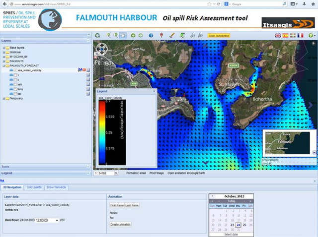
The Falmouth high resolution hydrodynamic model has been setup to give daily predictions; more specifically, 36 hours predictions of water level, water velocity, temperature and salinity. The web-based platform used to visualize these predictions is ITSASGIS 5D.
The ITSASGIS 5D platform includes the following general functions:
- Geographic navigation: zoom in, zoom out,pan, zoom to layer extent, go to previous zoom.
- Simple layer query.
- Change colour palette for gridded datasets, with transparency option.
- Navigation through multidimensional layers (depth and time)
- Animations and time series for multitemporal gridded layers
- Vertical profile graphs for multidepth gridded layers.
- Transect profiles for gridded layers.
- Add user custom markers.
- Draw & export vectorial kml.
Access to the platform: http://www.serviciosgis.com/i5d/visor/SPRES_fal

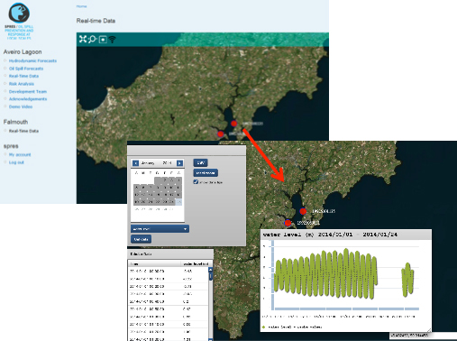
Ain the jurisdiction area of Falmouth Harbour, monitoring sensors in real-time exist (water elevation, wind, surface current speed and direction between other parameters). An interface for Falmouth real-time data (and in the future for the VOILS oil predictions) was developed under the SPRES/LNEC interface. This interface provides the same services available for Aveiro lagoon real-time monitoring network,
Risk assessment module
Similarly to other study areas, a risk assessment tool is under development. The maps and results of both the vulnerability and hazard components of the risk were uploaded in the web-based platform ITSASGIS5D. Currently, a plugin for calculation of risk based on the overlay of these components is under development.
The vulnerability assessment was performed considering the methodology of the NOAA’s ESI shoreline classification. The selection of each type of shoreline in the studied area was done based on the observations made during the field survey undertook at Falmouth site on June 2013. In term of ecological sensitivity, all the area of Falmouth-Fal estuary belongs to the Special Area of Conservation (SAC) Fal & Helford River. There are three Sites of Special Scientific Interest (SSSI) and a recommended reference area (maerl and Zostera marina beds) of St. Mawes bank. It is quite the whole area of Falmouth and Fal estuary which is of interest for birds. In term of socio-economy, oyster dredging, aquaculture, static gear fishing are activities very sensitive to oil pollution. Recreational sailing activity is widely developed in Falmouth Harbour and Fal estuary and tributaries. The great number of boats (could be up to 3 thousand) and the numerous marinas, slipways, pontoon, moorings linked to this activity maybe a real concern in term of response in case of an oil spill.


